The land in this area is fertile and well drained, with the rivers carving picturesque and attractive gorges through the Magnesian Limestone bedrock. Locally there is archeological evidence of settlement in Roman times. About ½ mile to the east overlooking Pleasley Vale is the site of aRoman villa whilst in the vicinity of Shirebrook a Roman building, pottery-kiln and coin hoard have been found.
When excavations for the mill owners large house at the west entrance to the vale itself began circa 1900, caves containing the bones of long extinct species of animals were found, whilst a little further to the north-east, at Creswell Crags, caves have yielded evidence of occupation by Neolithic man and, in 2003, the first British examples of palaeolithic cave art. A prehistoric route running via Skegby and Rotherham, along the flank of the Magnesian Limestone ridge, crosses the river Meden at Moorhaigh Bridge about ½ mile to the south-west and runs along the western edge of the old washery yard and the landscaped pit-tips where it is known as Longhedge Lane. Archeological investigations in the 1970s found evidence of a Roman road in this location.
The parish of Pleasley (Pleasley, Shirebrook, Stony Houghten) is quite an ancient one, although it does not appear in the Domesday Book - at that time it was part of the nearby Glapwell parish. It lies on the north side of the river Meden at the point where the alternative route of the old London to York road crosses it. To the south it is separated from the village of Pleasley Hill by the river, which was dammed here to form a reservoir for a water-powered corn mill, the remains of which can still be seen. A few 100m up the hill to the north, at the junction with the old Shirebrook and Teversal roads, the base and stump of the old market cross where sheep were sold at the two annual fairs still remain.
Prior to the 19th century, apart from the enclosure of common land, little change seems to have occurred over the years other than the ownership of the lordship of the manor. With the development in the late 18th century of a cotton mill at Pleasley Vale just to the east, however, the population began to increase steadily.
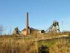
Following the sinking of the colliery at Pleasley, the villages of Upper Pleasley and New Houghten were created to house the miners and their families. These were expanded as the colliery developed with additional housing being constructed at Pleasley Hill. When the Deep Hard seam was opened in the 1920s further housing was built at Upper Pleasley to accommodate the enlarged workforce.
Introduction
This section gives a brief overview of the history of Pleasley up to the time of the opening of the colliery.

Pleasley parish circa 1843

Section under reconstruction
Page updated on:
07 Jul, 2026
at
11:57:51 AM
In case of problems contact:
Copyright © 2021 J.S. Thatcher
