see 1890 OS map detail showing Midland Railway extension
see 1899 OS map detail showing Great Northern Railway extension
1847 Tithe map of part of Pleasley township showing the field where the colliery was built, the route of the Midland railway extension from Teversal and the line of the Back Lane access road

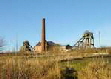
The principle landowner at Pleasley in the mid 19th century was the lord of the manor, W. E. Nightingale He owned 1159 acre (469.1 ha) out of the total of 1224 acre (495.4 ha) that comprised the manor. He agreed to lease the Top Hard coal lying beneath his land together with a large field known as Round Hill for the construction of the surface buildings. This field, along with other land totalling 197.5 acre (79.9 ha), had previously been farmed by William Sadler. It is not known whether he received any compensation for the loss of use of this substantial piece of fertile land.
Map of Pleasley Parish to go here
Alongside the eastern boundary of the field ran an occupation road which provided access to an isolated field to the north of the colliery as well as to a disused windmill located near the north-east corner of colliery site. Known to this day as Windmill Lane, this later became the principle vehicle access to the colliery. A pair of substantial houses were built for the colliery under-managers near the main entrance to the pit yard. A few years later, when the colliery had started to produce coal, a third house servicing a land-sale weigh bridge at the junction with the Mansfield to Chesterfield road was also constructed.
Map showing old windmill to go here
In addition, a narrow strip of land running to the south down the edge of the fields between Round Hill and Newboundmill Lane, along with a few other small pieces of adjoining land, was leased to allow the construction of a second access road, a row of colliery houses and various ancillary buildings.
Another narrow strip to the north and part of the adjacent fields to the west were leased to the Midland Railway for their branch line from Teversal and for the colliery sidings.
Sources :
- 1843 Tithe Map and Allocations, Derbyshire Records Office
- Mansfield and North Notts. Advertiser, 1877, 1879, Mansfield Library
- Stanton Ironworks Co. archives, Derbyshire Records Office
- An illustrated history of Mansfield’s railways. Anderson & Culpitt
- Stanton and Stavely, A Business History, S.D. Chapman
- The Andrews Pages: Kelley Directory, 1891
Housing :
It’s not entirely clear where the workers were living during the sinking. The 1875 1:2500 map shows a row of buildings on the LH side of what is now Terrace Lane to the south-west of the pit. This was the location of a small block of stone-built terraced houses on what was known as the Old Terrace. By 1879, however, contemporary accounts indicate that, in addition to the houses for the main officials near to the pit yard, the rest of the red brick houses on Old Terrace had by then been constructed.
By 1891 further houses had been built at Pleasley Hill and New Houghton for the steadily expanding workforce and the population of the Pleasley area had increased to 3293.
Electrification :
Pleasley Colliery was electrified at an early stage. In 1881 experimental use of incandescent lamps on the coal face took place. This was subsequently followed by the permanent installation of this type of lighting in the pit bottom and carbon-arc lighting on the surface. In 1890 a 84kW DC generator driven by a horizontal steam engine was installed near to the ventilation fans. This operated at 500 Volt, supplying the surface and underground lighting and powering a 60 hp (45 kW) haulage engine located near the pit bottom in the Top Hard seam.
Colliery > Start-up

Section under reconstruction

Page updated on:
30 Dec, 2025
at
01:21:00 PM
In case of problems contact:
Copyright © 2023 J.S. Thatcher